
Comprehensive Mapping and Data Solutions


What Is A Flood Risk Assessment Report?
For architects, land surveyors and developers it can be essential to provide a flood risk assessment report alongside planning permission applications. They support the site assessment development applications by looking at the risk and impact of flooding on a development site, helping to analyse the potential issues with building on sites, such as local areas having an increased chance of flooding for a flood check property report.
For a development to take place, the flood risk assessment report should prove that the site will remain safe in the future, taking the added effects of climate change into account when measuring the safety. When risks are found, the flood risk assessment report can provide possible solutions to the risk of flooding on the development, helping you to plan and safely bypass these risks
Choose the right report for you
Looking for the right Flood Risk Assessment Report package for you? At CentremapsLive, we have three FloodSmart assessment options, all giving clear flood management options and fast delivery times to help you prepare to manage risks that may occur on developments. Find out more about the different FloodSmart flood risk assessment report options below.
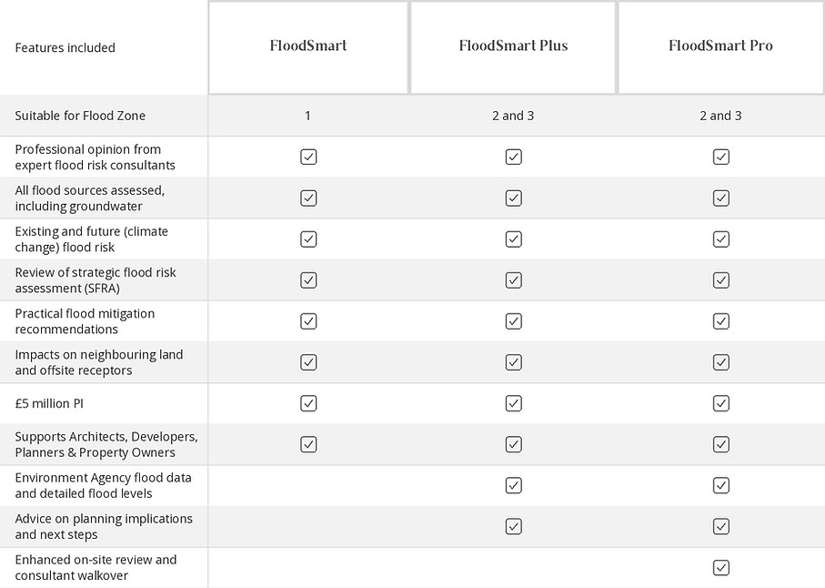
* pricing based on site size, location & complexity / ** Expedited turnarounds are available on request
GeoSmart FloodSmart: Planning-Focused Flood Risk Assessments
GeoSmart FloodSmart provides planning-ready Flood Risk Assessments for development sites across England and Wales. Designed for architects, developers, planners, surveyors and property owners, these assessments help establish whether flood risk could affect a proposed development and identify measures that may be needed to manage it.
A Flood Risk Assessment (FRA) is often required as part of a planning application, particularly where a site is located in an area identified as being at risk of flooding or where the proposed development may affect flood risk elsewhere. The assessment considers the site's location, proposed use, relevant planning policy and the potential effects of flooding throughout the development's lifetime.
GeoSmart's specialist assessments combine authoritative datasets with professional interpretation, helping identify potential constraints and provide practical recommendations at an early stage of a project.
What Does a GeoSmart Flood Risk Assessment Consider?
Flood risk can come from several different sources, so an assessment needs to consider more than whether a site falls within a designated river or coastal flood zone.
Depending on the site and the selected assessment, GeoSmart FloodSmart considers relevant information relating to:
-
River and coastal flooding: Potential flooding from rivers, the sea and associated flood defence information.
-
Surface water flooding: The potential for heavy rainfall to cause surface water accumulation and overland flow.
-
Groundwater flooding: Local groundwater conditions and susceptibility to groundwater emergence.
-
Sewer and drainage flooding: Relevant information about drainage infrastructure and potential sewer-related flood mechanisms.
-
Artificial sources: Potential risks associated with reservoirs, canals and other artificial water bodies.
-
Historic flood events: Available records of previous flooding in and around the site.
-
Climate change: How future changes in rainfall and flood conditions could affect the site's risk over its intended lifetime.
The assessment brings together relevant national datasets, local authority evidence and specialist interpretation to build a more complete picture of potential flood constraints.
Choosing Between FloodSmart, FloodSmart Plus and FloodSmart Pro
CentremapsLive offers three GeoSmart FloodSmart assessment options, designed to accommodate different site locations and levels of complexity.
FloodSmart: Flood Zone 1
FloodSmart is designed for lower-risk development sites in Flood Zone 1. It provides a professional assessment of relevant flood sources and considers the information needed to support planning decisions for sites in this zone.
FloodSmart Plus: Flood Zones 2 and 3
FloodSmart Plus is intended for sites in Flood Zones 2 and 3, where a more detailed assessment of flood risk is required. It considers relevant flood sources, existing and future conditions, and potential mitigation measures.
FloodSmart Pro: Enhanced Site Review
FloodSmart Pro builds on the assessment for sites in Flood Zones 2 and 3 by including an enhanced on-site review and consultant walkover. This provides additional site-specific insight where physical conditions and local circumstances need closer consideration.
The most appropriate option will depend on the site's flood zone, development proposals and planning requirements. If you are unsure which assessment is suitable, contact CentremapsLive before ordering.
Flood Risk, Climate Change and Development Planning
Planning authorities need to consider whether proposed development will remain safe over its expected lifetime, taking account of the potential effects of climate change. This means that an assessment should consider not only present-day flood conditions but also how future flood risk could change.
GeoSmart FloodSmart considers relevant existing and future flood risk information, helping identify potential constraints and areas where mitigation may be necessary. Where risks are identified, the assessment can provide practical recommendations to help inform the development design and planning process. Depending on the site, this may include consideration of finished floor levels, flood resilience measures, drainage and the management of surface water.
The findings can help architects and developers understand potential issues before committing to a detailed design or submitting a planning application.
Flood Risk Assessments for Architects, Developers and Planners
Flood risk information can influence decisions for architects & developers at several stages of a development project, from initial site appraisal through to planning submission and design development.
A GeoSmart Flood Risk Assessment can help:
-
Identify potential flood constraints when assessing a development site.
-
Provide information to support planning applications where an FRA is required.
-
Understand the potential effects of flooding from different sources.
-
Consider future flood conditions and climate change.
-
Identify potential mitigation measures and further investigation requirements.
-
Inform discussions with planning authorities and other project professionals.
Obtaining suitable flood risk information early can help identify issues before they become more difficult or expensive to address.
GeoSmart FloodSmart and Other Flood Risk Reports
The right report depends on the purpose of your assessment. GeoSmart FloodSmart is intended to support development planning and site-specific flood risk assessment, while other reports are designed for property transactions and different types of due diligence.
If you are assessing a home purchase, a Residential Flood Report provides information about flood risk in a residential property context. For commercial property transactions and due diligence, see the Commercial Flood Report.
You can also explore the full range of Flood Risk and SuDS Reports available from CentremapsLive.
Sample
Consult Form